Highland Village is the retail area that centers around the intersection of Ford Parkway and Cleveland Avenue in Saint Paul, MN. It is a fairly diverse area, with both new and older retail serving a variety of needs. Recently the area started to undergo a major reconstruction project involving the public sidewalks. As a frequent visitor of the area I thought it would be interesting to document the changes, so here are some photos:
First a couple of photos showing the original concrete and red brick sidewalks. This design was incorporated in the 1980s if I recall correctly:
Next are a couple of shots showing some of the completed and somewhat completed sidewalks so far:
Finally, one section that will be interesting to watch, the future site of the northbound/eastbound A-Line bus station/stop on Ford Parkway at Finn Street. I recall some mention of roughing in station elements with the sidewalk rebuilding, however there has also been mention of station construction occurring next year when Ford Parkway is being repaved/rebuilt. How much is being done now vs. later at this spot is unknown to me. However it is nice to see that the A-Line station is being taken into account. I'd rather see a temporary asphalt or concrete pad in place for now, rather than have a complete new sidewalk and curb ripped out next summer. Of course the best thing would be to pre-build part of the platform ahead of time so as to minimize pedestrian interference.
Looking west at the station site:
East view:
A mark on the Highland Bank plaza noting where the BRT section cutoff is:
Tuesday, September 16, 2014
Wednesday, September 3, 2014
How About a People Mover at the Mall of America?
The Mall of America (MOA) is one of the largest indoor shopping malls in the United States, and it's getting larger. Currently the MOA boasts 4.87 million square feet of building area, making it one sizable chunk of property. Access to the MOA is typically by auto, mass transit, or tour bus, although a few pedestrians and cyclists have been spotted on occasion. With more expansion comes more active groundspace, longer walking distances, and of course, parking spots. Additional transit access or coverage is not really included however, with the only future transit plans at MOA calling for an update to the current transit station and garage area.
With that in mind, it seems like our big retail friend and tourist hotspot could use something beyond simple pavement and walkways to move visitors around. Walking around the MOA as it is can be tiring, with each floor clocking in at 0.57 miles in distance. While this is fine if you're super hyped about scoring those awesome shoes or actually remembering to buy your girlfriend a nice present for her birthday, it can be kind of a drag if you are coming in to start an eight hour shift at work, or just stopping by to get a new tie. Add in the extra distance to future development, and suddenly scoring that parking space 150' feet closer to the door doesn't seem like a big difference.
Incorporating an automated people mover tram system could provide a beneficial transportation solution. My proposal is to connect the IKEA store, the new expansion area, and the MOA core with a new and improved MOA transit station at the existing 28th Avenue site. The mover would operate at frequencies of about 90 seconds to 120 seconds ideally.
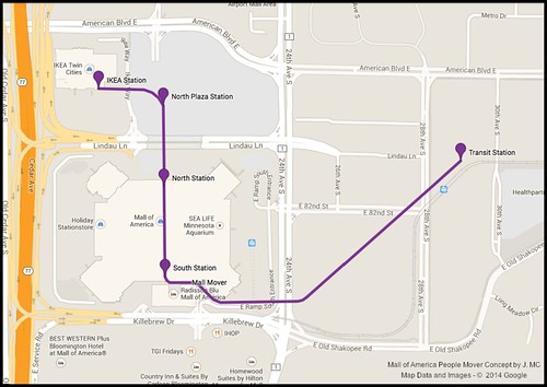
Stations or stops on the line would be at IKEA, the North Plaza expansion area, the north entrance, the south entrance, and 28th Avenue MOA Transit Station. Benefits to mall visitors would be quick access between IKEA, the new expansion development, and the mall core.
While the existing MOA transit station would be removed under this plan, there would still be some improvement for transit riders. Currently the Metro Transit Blue Line takes about four minutes to travel from 28th Avenue to the MOA platform. Add another two to three minutes of walking up the stairs, across the inner access road, and into the mall, and it can be six to seven minutes minimum to actually get to your destination. However if riders could instead transfer to the mover and take a one to three minute ride to their destination that would make it easier. Time savings would be even better for those who want to go to the north end or IKEA. This could also improve transit operations as well, cutting about eight to ten minutes off a roundtrip on the Blue Line, and creating a better transit station with direct access for buses currently serving the MOA. (Many of which already circle the block by 28th St. currently)
Parking for the MOA could also benefit from this line. Instead of wasting valuable nearby space on the Mall grounds for more parking spaces, that area could instead be used for additional retail space. Parking could instead be added out by the 28th Avenue site, perhaps in the form of a combined MOA and park and ride ramp to get more use out of the spaces. (Park-Ride user in the daytime, mall shopper in the evening.)
While this plan is likely to never be more than a simple Google doodle, I hope that the most notorious and largest shopping mall in the United States will incorporate other modes of transportation, and consider walkability, as it continues on with an ever widening footprint.
With that in mind, it seems like our big retail friend and tourist hotspot could use something beyond simple pavement and walkways to move visitors around. Walking around the MOA as it is can be tiring, with each floor clocking in at 0.57 miles in distance. While this is fine if you're super hyped about scoring those awesome shoes or actually remembering to buy your girlfriend a nice present for her birthday, it can be kind of a drag if you are coming in to start an eight hour shift at work, or just stopping by to get a new tie. Add in the extra distance to future development, and suddenly scoring that parking space 150' feet closer to the door doesn't seem like a big difference.
Incorporating an automated people mover tram system could provide a beneficial transportation solution. My proposal is to connect the IKEA store, the new expansion area, and the MOA core with a new and improved MOA transit station at the existing 28th Avenue site. The mover would operate at frequencies of about 90 seconds to 120 seconds ideally.
Stations or stops on the line would be at IKEA, the North Plaza expansion area, the north entrance, the south entrance, and 28th Avenue MOA Transit Station. Benefits to mall visitors would be quick access between IKEA, the new expansion development, and the mall core.
While the existing MOA transit station would be removed under this plan, there would still be some improvement for transit riders. Currently the Metro Transit Blue Line takes about four minutes to travel from 28th Avenue to the MOA platform. Add another two to three minutes of walking up the stairs, across the inner access road, and into the mall, and it can be six to seven minutes minimum to actually get to your destination. However if riders could instead transfer to the mover and take a one to three minute ride to their destination that would make it easier. Time savings would be even better for those who want to go to the north end or IKEA. This could also improve transit operations as well, cutting about eight to ten minutes off a roundtrip on the Blue Line, and creating a better transit station with direct access for buses currently serving the MOA. (Many of which already circle the block by 28th St. currently)
Parking for the MOA could also benefit from this line. Instead of wasting valuable nearby space on the Mall grounds for more parking spaces, that area could instead be used for additional retail space. Parking could instead be added out by the 28th Avenue site, perhaps in the form of a combined MOA and park and ride ramp to get more use out of the spaces. (Park-Ride user in the daytime, mall shopper in the evening.)
While this plan is likely to never be more than a simple Google doodle, I hope that the most notorious and largest shopping mall in the United States will incorporate other modes of transportation, and consider walkability, as it continues on with an ever widening footprint.
Monday, July 28, 2014
Arbor Pointe of Inver Grove Heights, MN
Having observed the Arbor Pointe development over the years, and having read this article published in the Pioneer Press a few months ago, it seemed a photo stop was in order to document some of the closures in the area. The following photos were taken about a week ago:
Rainbow Foods, while not a part of the actual Arbor Pointe retail section, was one of the first major businesses to move into the area following housing development. Walmart was the other big business to proceed the development, however a photo was not obtained of that store.
This Rainbow was one of nine in the Twin Cities area that failed to attract any buyers following the decision by Roundy's to sell the chain.This store was originally built in the late 1990's, and seemed to do well in its early years. During the recession however they seemed to struggle to attract a steady amounts of customers. For example, when only one of the 15 checkout lines is open, and there's a bell sitting on the conveyor to summon a cashier, you can tell the store is not very busy.
The main sign for the Arbor Pointe Retail Center, seen on the corner of Concord Blvd. and Broderick Blvd.
Walgreens closed their Arbor Pointe location after ten years in business.My guess is a lack of steady drive up business and strong competition from the Walmart across the street lead to its demise.
Two other Walgreens are still going in Inver Grove, and while both are over towards the north end of town, there may have been some over-saturation of the brand.
Advance Auto Parts is another victim, this store closed last year. A Discount Tire is located across Broderick Blvd, so that may have had some impact. Otherwise the lack of easy access into the Arbor Pointe development probably took customers elsewhere.
A&W, this one had multiple strikes against its success. The restaurant was located in the interior of the development, limiting visibility from the major streets. Management was also a problem here in my opinion. Poor service and poor quality food are not going to keep customers coming back.
The one business that does seem to do well here is banking. Wells Fargo built a branch here in the mid 2000's or so, and is still active today. Another bank also opened a branch here, however they closed the location after a few years. Associated Bank finally leased or bought the building recently though, and seems to be flourishing.
It is worth noting that Ruby Tuesday, and a few specialty shops still survive in the development. A new multistory senior living apartment complex was also recently added.
What is in store for Arbor Pointe in the future is unknown. If residential development in the area continues to sit without much activity, then there probably won't be much action. If demand does pick up once again, then there will probably be a bit of a retail renaissance. While I'm no development expert, in my opinion a few improvements can be made in the design and layout of the development. The mish-mash of individual lots for each store seems confusing and counterproductive. If I want to grab a new brake light bulb, and then pick up a bottle of asprin at a drugstore, I'm much more likely to go to a location where I can park my car and then walk to each store, instead of pulling into one lot, and then moving the car 500' feet to the other lot, and then driving across the street to grab a snack.
Tuesday, March 11, 2014
2012 Minnesota Transit Systems Cost Per Ride Comparison
It is time once again for my annual Minnesota Dept. of Transportation Transit Report system cost comparison. As before the overall focus of this bit of information is on comparing fixed-route operations from the various agencies across the state. A comparison of 2011 costs can be seen here. This is only a small part of the information contained in the report. If you have an interest in learning more about these and other transit providers in Minnesota I recommend reading the report in its entirety.
| 2012 Cost Per Ride Comparison for Minnesota Fixed-Route Transit Providers | |||
| Provider | Operating Expenditures | Ridership | Cost/Ride |
| UNIVERSITY OF MINNESOTA TRANSIT | $6,080,021 | 3,197,701 | 1.90 |
| WINONA TRANSIT SERVICE* | $597,320 | 255,132 | 2.34 |
| METRO TRANSIT: LRT | $27,886,232 | 10,498,236 | 2.66 |
| ST. CLOUD METRO BUS | $6,295,883 | 2,230,106 | 2.82 |
| GREATER MANKATO TRANSIT SYSTEM | $1,556,183 | 449,930 | 3.46 |
| ROCHESTER PUBLIC TRANSIT | $6,083,428 | 1,739,071 | 3.50 |
| MOORHEAD METROPOLITAN AREA TRANSIT | $1,533,055 | 436,285 | 3.51 |
| METRO TRANSIT: BUS | $245,215,781 | 69,069,539 | 3.55 |
| DULUTH TRANSIT AUTHORITY | $12,390,741 | 3,155,423 | 3.93 |
| METROPOLITAN TRANSPORTATION SERVICES | $13,477,072 | 3,033,902 | 4.44 |
| MAPLE GROVE TRANSIT | $4,220,797 | 826,879 | 5.10 |
| MINNESOTA VALLEY TRANSIT AUTHORITY | $17,936,636 | 2,575,363 | 6.96 |
| PLYMOUTH METROLINK | $3,589,498 | 496,964 | 7.22 |
| EAST GRAND FORKS TRANSIT*** | $266,588 | 36,847 | 7.23 |
| SOUTHWEST TRANSIT | $7,799,059 | 998,960 | 7.81 |
| METRO VAN POOL** | $1,416,216 | 179,013 | 7.91 |
| LAKER LINES | $945,816 | 96,513 | 9.80 |
| LA CRESCENT APPLE EXPRESS**** | $260,690 | 25,749 | 10.12 |
| SHAKOPEE TRANSIT | $1,276,055 | 125,557 | 10.16 |
| RUSH LINE | $385,081 | 37,015 | 10.40 |
| RAMSEY STAR EXPRESS***** | $567,616 | 42,263 | 13.43 |
| TRANSIT LINK** | $6,658,057 | 312,639 | 21.30 |
| METRO TRANSIT: NORTHSTAR | $16,419,740 | 700,276 | 23.45 |
| Notes: *Winona operates service under contract for WSU and St. Marys **Not fixed-route service, included due to being part of overall Twin Cities Metro area system structure ***EGFT service operated under contract by Cities Area Transit ****Apple Express operated under contract by La Crosse MTU ***** Ramsey service discontinued with opening of Ramsey Northstar station | |||
| Source: 2013 Transit Report - A Guide to Minnesota’s Public Transit Systems (MnDot) | |||
| http://www.dot.state.mn.us/transit/reports/reports-publications/report-2013.pdf | |||
Tuesday, March 4, 2014
If this is the A Line, then why do the stations look like a C-?
Metro Transit is currently seeking public input on station design for the A Line. While encouraging public input is commendable, the proposed choices leave something to be desired. Unfortunately it seems the A Line station designs are stuck in the ‘sometimes the end result is not so great, but we tried’ attitude already seen throughout the system. “What causes this to happen?” well here’s my educated guess on what the design teams have to work with:
For starters the rules, or at least what seem to be the rules based on my observations, regarding shelter design and placement:
- When possible the shelter should be placed on the curb so as to be extra prone to snowplow damage, and to block the rear door of the transit vehicle.
- The shelter should be positioned with the opening towards whichever direction has the most wind and precipitation.
- There needs to be an adequate gap between the ground and the bottom of the shelter wall to ensure extra airflow through the shelter, and to allow snow and road slop to better infiltrate the floor of the shelter.
- When feasible there should also be a gap between the top of the walls and the roof of the shelter. For example, the bus shelters adjacent to the train platform at 46th Street Station.
- Benches in the shelter must be metal, to provide the customer with a complete outdoors experience, as though they are sitting on a block of ice.
- If heaters are installed in the shelter they must be placed as high from the ground as possible. Ideally a customer with above average height should just barely have their hat warmed when standing directly below the heating element.
- If extra money is available to spend on the shelter, it must be used for a feature that does nothing to further protect patrons from the elements, such as an exotic stone floor or copper roof trim.


(Examples of some of the not so nice bus shelters found at various stops. These are maintained by CBS Outdoor, with the CBS apparently standing for Crumby Billboard Shelter.)
From these rules one can understand why the shelter concepts are all basically the same. We can pick between four shelters that look as though they are designed by someone who has never had to wait at a stop for 20 minutes in a subzero wind chill, or a horizontal rainstorm, during a weather delay.
Now how about those station identifiers, or pillars, or pylons, or whatever the tall box things are? Well these are certainly an improvement over the traditional bus stop sign, but again they are fairly uncreative. Sure, they can probably pick those up cheap on the BRT Lite aisle at Transit Depot, but we can do better than a box with a curve on the top. Heck, boring old Inver Grove Heights put a similar style of pillar along Cahill Avenue years ago to notify passerby that Cahill is ‘Main Street’. (Suburbs have to label that stuff.)
We need to get creative with those station identifiers; we need something that screams, MINNESOTA! Ooh, how about a giant Paul Bunyan statue for each station? That would be unique. No, wait, if Paul hung around the stops on Snelling too much he might start wearing baggy pants dropped down to his crotch and a wifebeater shirt, and that look just wouldn’t suit him. Hmm, a giant green Adirondack chair? Nah, then Metro Transit would start getting angry calls from riders waiting by the original ones wondering where the bus was. Minnesotans like big things though, mcmansions, SUVs, Target stores, we have the biggest shopping mall, a giant spoon... Bingo! Put a huge bus stop sign at each stop, it can complement our oversized art, house a NexTrip screen, and meet ADA font size requirements.
Better yet, we could just accept the design given and just bundle up for the weather. Really, what is more Minnesotan than a modest transit stop, with some hardy natives bundled head to toe, waiting for a ride to the hockey game?
For starters the rules, or at least what seem to be the rules based on my observations, regarding shelter design and placement:
- When possible the shelter should be placed on the curb so as to be extra prone to snowplow damage, and to block the rear door of the transit vehicle.
- The shelter should be positioned with the opening towards whichever direction has the most wind and precipitation.
- There needs to be an adequate gap between the ground and the bottom of the shelter wall to ensure extra airflow through the shelter, and to allow snow and road slop to better infiltrate the floor of the shelter.
- When feasible there should also be a gap between the top of the walls and the roof of the shelter. For example, the bus shelters adjacent to the train platform at 46th Street Station.
- Benches in the shelter must be metal, to provide the customer with a complete outdoors experience, as though they are sitting on a block of ice.
- If heaters are installed in the shelter they must be placed as high from the ground as possible. Ideally a customer with above average height should just barely have their hat warmed when standing directly below the heating element.
- If extra money is available to spend on the shelter, it must be used for a feature that does nothing to further protect patrons from the elements, such as an exotic stone floor or copper roof trim.
(Examples of some of the not so nice bus shelters found at various stops. These are maintained by CBS Outdoor, with the CBS apparently standing for Crumby Billboard Shelter.)
From these rules one can understand why the shelter concepts are all basically the same. We can pick between four shelters that look as though they are designed by someone who has never had to wait at a stop for 20 minutes in a subzero wind chill, or a horizontal rainstorm, during a weather delay.
Now how about those station identifiers, or pillars, or pylons, or whatever the tall box things are? Well these are certainly an improvement over the traditional bus stop sign, but again they are fairly uncreative. Sure, they can probably pick those up cheap on the BRT Lite aisle at Transit Depot, but we can do better than a box with a curve on the top. Heck, boring old Inver Grove Heights put a similar style of pillar along Cahill Avenue years ago to notify passerby that Cahill is ‘Main Street’. (Suburbs have to label that stuff.)
We need to get creative with those station identifiers; we need something that screams, MINNESOTA! Ooh, how about a giant Paul Bunyan statue for each station? That would be unique. No, wait, if Paul hung around the stops on Snelling too much he might start wearing baggy pants dropped down to his crotch and a wifebeater shirt, and that look just wouldn’t suit him. Hmm, a giant green Adirondack chair? Nah, then Metro Transit would start getting angry calls from riders waiting by the original ones wondering where the bus was. Minnesotans like big things though, mcmansions, SUVs, Target stores, we have the biggest shopping mall, a giant spoon... Bingo! Put a huge bus stop sign at each stop, it can complement our oversized art, house a NexTrip screen, and meet ADA font size requirements.
Better yet, we could just accept the design given and just bundle up for the weather. Really, what is more Minnesotan than a modest transit stop, with some hardy natives bundled head to toe, waiting for a ride to the hockey game?
Subscribe to:
Posts (Atom)